Assam: What’s in a name when problems remain the same for Guwahati?
Guwahati, May 19, 2017: So one fine day I land in Guwahati only to find out that most of the city's pubs and restaurants are located at Mahapurush Srimanta Sankardeva! It makes me wonder, Mahapurush Srimanta Sankardeva from Guwahati-Shillong Road? I begin to look around for latest news updates on changed road names in Guwahati and find this:

As the current government in Assam is on a spree of missions to formulate as well as implement policies for its residents, some decisions of the BJP led government has drawn flak from certain sections of the society. One among them is the government's move to rename as many 10 prominent roads of Guwahati city.
While the lifeline of Guwahati- the Guwahati-Shillong road is renamed after Mahapurush Srimanta Sankardeva (Vaishnavite saint) path, road from Ganesh Mandir via Kahilipara to Lalganesh is renamed as Pandit Deendayal Upadhyaya path. Assam trunk road (Bharalumukh to Paltan Bazar) is named after Vashnavite saint, Mahapurush Damodar Dev Path. Road from Kharguli to Noonmati is named after music maestro, late Dr Bhupen Hazarika. Sijubari Path is renamed after Chaolung Sukapha, the founder of Ahom kingdom in Assam. Beltola-Khanapara road is named after Pir Ajan Fakir, who was Sufi Syed.
In an attempt to free the roads from the names of the British era, this move was taken by the government as per a government official. Here are few facts about roads in Guwahati that one needs to know:
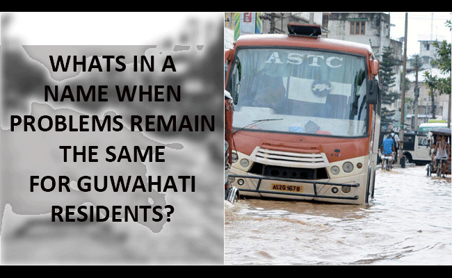
Despite bring in the list of 'Smart Cities' , Guwahati is yet to find answers to floods in and around the roadways due to lack of a proper drainage system. The poor drainage system is such that even a 30-minute shower seems to inundate roads making it difficult for residents to ply on the streets. Low-lying localities like Anil Nagar, Nabin Nagar, Tarun Nagar and Zoo Road Tinali, parts of GS Road, Ganeshguri, parts of Hengerabari, Hatigaon, Birubari, Maligaon, VIP Road, Panjabari Road, Express Highway and Maligaon usually get submerged during monsoon due to lack of proper drainage system.
It may be mentioned that during the month of July in 2016, two localities in Guwahati, Anil Nagar and Nabin Nagar were almost entirely submerged — not by the waters of Brahmaputra but due to artificial flooding caused by heavy rains and complicated further by a poor drainage system. This in turn necessitated the supply of food and drinking water by the authorities. Boats were also used to rescue and transport the aggrieved. In many other localities, residents also suffered flash floods and water logging, something which was unheard of in the city for almost 25 years.
Guwahati is said to brag about 24×7 drinking water, a proper stormwater drainage system, a modern and scientific sewerage system and improved public transport and traffic infrastructure. But the bitter truth as reported by the Telegraph is that only 25% of Guwahati's residents get piped drinking water, while no organised sewerage system exists.
"Guwahati is a bowl-shaped city where water stagnation is a natural phenomenon. Rains bring down a lot of silt from the hills, which in turn quickly fills up the city's drains…..," admitted state chief secretary Vinod Kumar Pipersenia.
A study by Columbia University's Earth Institute three years ago had identified the absence of a clearly laid-out drainage system as one of the major reasons behind urban floods in Guwahati, in addition to encroachment of the hills and wetlands.
As reported by the Indian Express, legislations aimed at tackling the problem — Assam Hill Land and Ecological Sites (Protection and Management) Act of 2006 and Guwahati Water-bodies (Preservation and Conservation) Act of 2008 — remain only on paper. The 2006 Act blames destruction of hill land for heavy erosion, landslides and soil movement with rainwater, while the 2008 one says all this has been caused by encroachment and aggravated the problem of artificial floods. Nearly a decade later, not one significant eviction drive has been carried out under these Acts.
The government has often admitted that over 80 per cent of the 19 hills in the city have been encroached, and some portion of land even regularised by influential people. The area of the water-body Deeper Beel, the Northeast's only Ramsar Site, has shrunk from about 42 sq km to less than a fourth, just about 10 sq km, while the Barsola, Sarusola and Silsako beels too have shrunk rapidly in recent years.
Encroachment by a large number of private individuals is one thing; the state government too has allotted land to many public and private institutions and firms in the wetlands. A youth hostel, for instance, was constructed on the Barsola Beel in the 1980s, while the government allotted land to Bhupen Hazarika, Assam Tennis Association, Asam Sahitya Sabha, Ginger Hotel, OKD Institute of Social Change and many other institutions on the Silsako Beel.
Hundreds of industries, warehouses and multi-storey apartment buildings, meanwhile, have wiped out the most part of Deeper Beel. And to add to the greater woes of people by changing the names of streets, it would have been better if something more was done to improve the drainage system before the arrival of the monsoon season. After all, whats in a name when problems remain the same?
–By Shweta Raj Kanwar with inputs from Indian Express
The writer can be reached at shweta@thenortheasttoday.com
The opinions expressed in the article are the writer's own and TNT- The Northeast Today may not necessarily hold the same views